Zoning
Zoning Defined
Portland’s zoning code describes what you can build on a Portland property, including, of course, Bridlemile property.
The code defines many things, such a building’s allowed uses, conditional uses, and prohibited uses. It also covers maximum height, floor size, setback (front yard size) and much more.
Zoning in Bridlemile
Much of Bridlemile is zoned for relatively large residential lots. An August 30, 1956 Oregon Journal article stated:
“The city council has adopted a planning commission recommendation that lot sizes in the recently annexed Bridlemile area of southwest Portland be restricted to a minimum of 10,000 square feet (equivalent of a 100x100 lot).
The residents asked for the restriction to retain the present character of the neighborhood.”
While such 10,000 minimum lot size zoning can help “to retain the present character of the neighborhood”, it also can restrict availability of residences to more economically-advantaged people by making legal only buildings with large lot sizes and/or large building sizes, which only such people can afford. This may tend to limit a neighborhood’s economic diversity.
Also, zoning can influence use of cars, public transportation, or walking. In Bridlemile, ~1,755 land parcels are zoned for single-family residential use – and many, especially with those zoned for larger lot sizes (R10 and R20) are located near the mid- (Hamilton Street) and northern (Patton Road) part of the neighborhood.
However, the ~16 land parcels zoned commercial (late 2025) are located along the southern boundary – SW Beaverton-Hillsdale Highway. They include restaurants and retail establishments, such as in the Raleigh Hills Shopping Center (and an unfortunately large number of currently vacant buildings). As a result, many residents, especially in those mid- and northern parts of the neighborhood, are a relatively long walk from restaurants, retail outlets, bus lines – and from the grocery store and drug store that may one day again be on SW Beaverton-Hillsdale Highway. This increases the likelihood that those residents will use cars to reach such destinations.
Bridlemile has ~51 land parcels zoned for multi-family residences (RM1 and RM2). This includes apartment complexes, four-plexes, tri-plexes, duplexes, and row houses – all near SW Beaverton-Hillsdale Highway and somewhat conveniently located to existing commercial establishments on both sides of the highway (Bridlemile and Hayhurst). Also, they are conveniently located to TriMet’s frequent-flyer bus 54 and bus 56 service.

R20: Minimum of 20,000 square foot lots for single-family residences
R10: Minimum of 10,000 square foot lots for single-family residences
R7: Minimum of 7,000 square foot lots for single-family residences
R5: Minimum of 5,000 square foot for single-family residences
CM1: Commercial/Mixed Use 1
CM2: Commercial/Mixed Use 2
CE: Commercial employment
OS: Open space (parks and nature areas)
RM1: Multi-family residences
RM 2: Multi-family residences
The above graph shows that most property lots in Bridlemile consist of either R10 or R7 zoned single-family residences.
Zoning: Portland Code
The Portland Bureau of Planning and Sustainability writes/maintains the zoning code.
The actual code is at: https://www.portland.gov/code/33
The Portland Department of Permitting and Development administers the code.
For free 15-minute appointments to ask permit, code, zoning questions:
https://www.portland.gov/ppd/early-assistance/15-minute-question-appointments
To access the Portland zoning code itself:
https://www.portland.gov/code/33
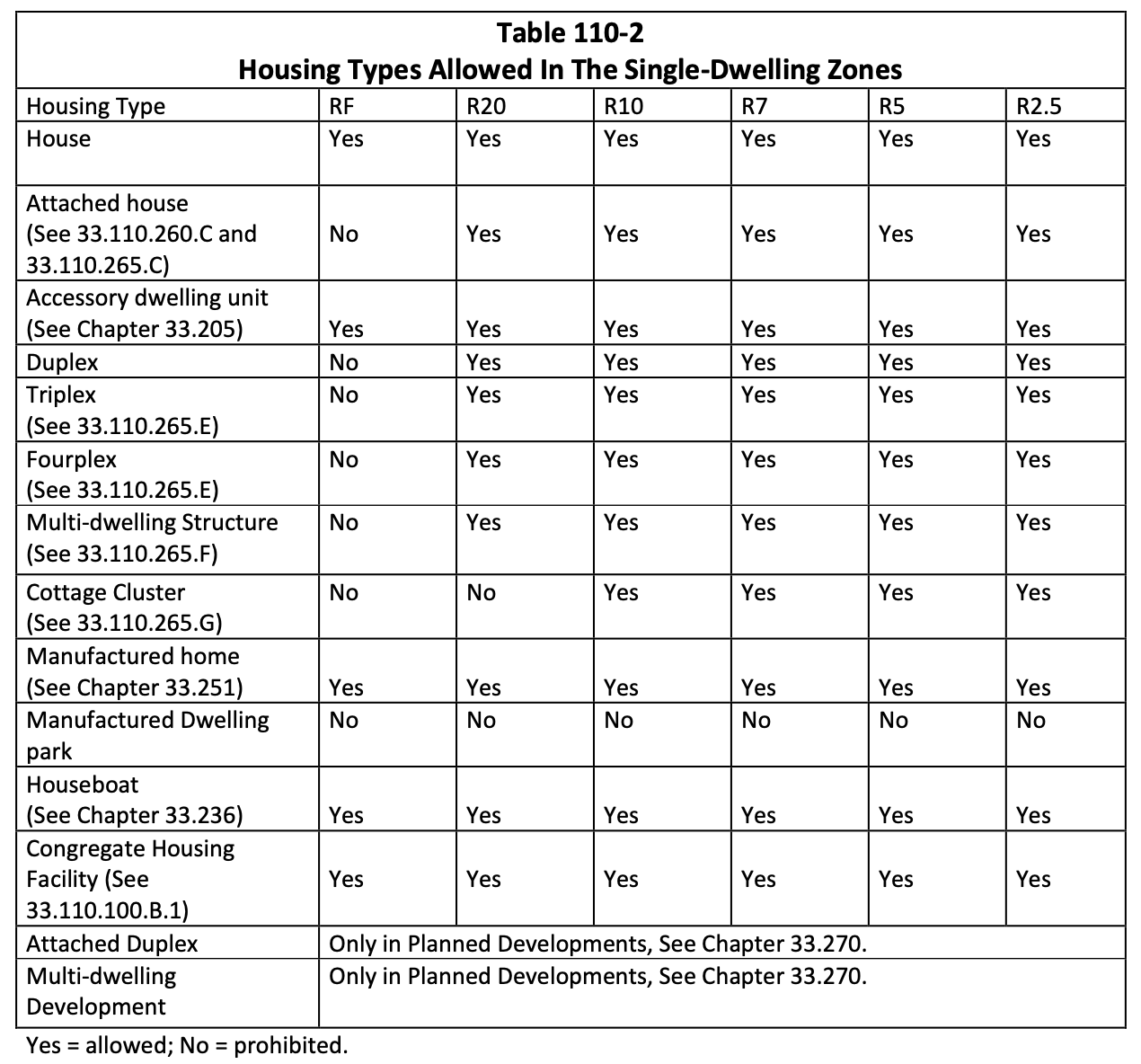
To access tables that describes the uses of housing in each zone area:
To access the Portland zoning map:
https://www.portlandmaps.com/bps/zoning/#/map/

The map shows every Bridlemile property parcel in a color that matches its zone.
Yellow represents single-family residences, with each shade representing a different residential code. The more pale-yellow parts represent larger R10 lots, generally located in more northern areas. The more yellowish colors represent R7 lots, generally located in more southern areas of the neighborhood.
Blue shades represent classes of multi-family residences (e.g. apartments , townhouses, etc.) and located near Beaverton-Hillsdale Highway.
Rust/red/orange shades show codes for commercial properties, also near Beaverton-Hillsdale Highway.
Green shows parks and natural areas. All four quadrants of the neighborhood contain at least one park or natural area.
Zoning: A Short History:
New York City passed the nation’s first city-wide zoning code in 1916. Cities and states around the country followed and passed their own codes in the 1920’s.
Zoning: Portland in 1924:
In 1924, Portland passed its initial zoning code. They did this after about eight years of discussion and after a failed vote in 1920.
The 1920 vote apparently failed because voters found the system too complicated. Portland’s government came up with a simpler code in 1924. That code used only four types of zones.
Zone one covered single-family residences,
zone two covered multi-family residences, e.g. duplexes,
zone three covered commercial enterprises, and
zone four was for industrial areas.
An early proponent of having Portland establish a zoning code wrote: “No district, however hallowed it might be in itself by tradition or vested interested was sacred against the invasion of some giant loft building and garish with signs flaunting strange sounding names. Any respectable apartment colony could never be sure that the next month would leave on its door step a “Temple of Gasoline” filled to the roof with snorting machines. The freedom of choice on the part of the individual lot owner to do as he pleased with his own was in its full flower and fruit. No man’s property was safe from the ignorance or selfishness of his neighbors and it meant real estate anarchy as a similar condition in politics means governmental anarchy.” The Oregon Sunday Journal. March 18, 1917
“Individual property owners are helpless. The establishment of a zone ordinance will do for the individual what he cannot now do for himself – set up uniform restrictions that will protect each against his neighbor and benefit all” Oregon Journal. November 5, 1919.
Zoning: Portland in 1959:
In 1959, Portland approved a revised code. Compared to the 1924 code, it was more elastic and more complicated, with more categories to handle more cases.
Critics of the 1924 code said it was inflexible and allowed conflicts at the borders of zones, where “fine homes” could exist near a noisy machine shop. (Oregonian, 5-15-1951)
In calling for a replacement for the 1924 code, Commissioner Bowes gave a speech where he “stressed the need for ‘flexibility’ in a workable zoning ordinance. Zoning is designed to protect property, not restrict its use, he said. “It has become more and more apparent that the four zones now existing do not give a proper distribution for the community needs, that they are too rigid and too encompassing in the uses of land to do the job necessary in a progressive city.” Oregon Journal. December 17, 1954.
For example, additional types of zones for additional types single-family residences were added. These required larger lots for single-family residences in areas like Bridlemile. It did this by creating expanded codes to require areas have much larger single-family lots. They called for minimums of 7,500, 10,000 and 20,000 square feet, which was considerably larger than generally needed on the east side of town.
“The City Council voted in the 1950s to expand single-family-only zoning to many of the city’s neighborhoods.” 2020-08-14. Oregonian
The new code also restricted the size of multi-family housing, including apartments. “To guard against slums, population density will be restricted by the new code. There is now no regulation against this. ‘The foremost factor creating slums,’; Keefe said, ‘is the crowding of more and more people into smaller and smaller zones.’ The new code restricts apartment house floor space to a proportion of the land area occupied.” Oregon Journal. 4-21-1959.
Commisioner Bowes said, “We have had too much land zoned for multi-family uses, poor commercial zone distribution and insufficient regulation of apartment construction. The old regulations were written in streetcar days 35 years ago before heavy vehicular traffic, before the shopping centers, and for a different way of life.” (Oregon Journal. 1959-05-30)
At time 2:22: “In 1959, Portland City Council basically got rid of the duplexes, triplexes and four plexes. Said you couldn’t build them anymore. And almost everything built since had to be a single family home. Now this made for more desirable neighborhoods, which over time made them more and more expensive. Simple supply and demand. It also prolonged the segregation of our communities. And encouraged aggressive gentrification that prices people out of the neighborhoods that their people helped build.”
KGW- Examining Portland’s latest housing plan
Zoning: Portland in 2021 – Residential Infill
In 2019, the Oregon Legislature passed a bill to expand the types of housing people can build. It called for cities in the Portland metro area and in other large Oregon cities to “allow people to build duplexes, triplexes, fourplexes, cottage clusters and townhouses in residential areas.” The intent was that “these houses can be more affordable and meet the housing needs of many younger people, older people, and people who work hard but can’t afford a large detached house of their own.” Oregon.gov: HB2001 Overview
“Middle housing does lower construction costs: shared walls, smaller footprints,” (Governor) Kotek said. 2025-01-19. Oregonian.
In 2020, the Portland City Council passed its Residential Infill Project (RIP). It went into effect on August 1, 2021. Portland.gov: Residential Infill Project (RIP)
“The policy will allow up to four homes on nearly every residential lot, and six units if three of them are affordable to low-income families.” Willamette Week. August 12, 2020.
Portland’s Residential Infill Project:
requires smaller houses to better fit existing neighborhoods,
creates more housing choices for people changing needs,
establishes clear and fair rules for narrow lot development
Portland.gov: About the Residential Infill Projec
For more details, see the Portland.gov article titled:
Residential Infill and Middle Housing Land Divisions in Single-Dwelling Zones
“Commissioner Amanda Fritz was the sole no vote against the plan, calling it one of the most upsetting votes she’s cast in her dozen years on the Council. While many environmental groups had rallied around the plan to increase density, Fritz said she believed the final proposal would worsen the climate crisis by allowing houses to be built far from transit routes and commercial corridors.
‘This Council is voting for changes that throw out 40 years of land use planning in Portland by adding more density without regard for access to transit and services,’ she said.
Portland Mayor Ted Wheeler and Commissioners Jo Ann Hardesty and Chloe Eudaly each voted in support of the plan, which they framed as a necessary way to deal with Portland’s housing scarcity and a righting of racist and exclusionary zoning policies that have long governed growth in Portland.”
OPB, October 22, 2025 - Portland overhauls zoning code to allow for duplexes, triplexes, fourplexes