The Neighborhood
Portland has 94 officially recognized areas of land called neighborhoods. Each has its own population demographics and physical look and feel.
The Bridlemile neighborhood resembles in ways those promoted by noted urban designer Clarence Perry in 1929. He envisioned a city unit called a neighborhood in his writings.
Clarence A. Perry, "The Neighborhood Unit," Neighborhood and Community Planning, (VII), (New York: Committee for the Regional Survey of New York and its Environs, 1929).

Clarence Perry’s 1929 ideal neighborhood design and Bridlemile’s 2025 design
Mr. Perry advocated for:
1. Keeping major roadways to the perimeter of residential neighborhoods. That way, they would define the neighborhood boundaries, rather than disrupt pedestrians inside the neighborhood.
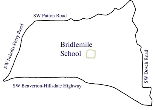
Pros: Bridlemile’s major roadways run along its perimeter. The southern boundary is the busy four-lane Beaverton-Hillsdale Highway. On the west is the busy Scholls-Ferry Road (mostly four lanes). The key arterial routes of Patton Road to the north and Dosch Road to the east mark other boundaries.
The rapid bus service on Beaverton-Hillsdale Highway connects residents with downtown and Beaverton workplaces and shopping.
In contrast, its two big internal (connector) streets, Hamilton Street and Shattuck Road, both have speed bumps and lower speed limits than the boundary streets. Thus, while they carry more traffic than other internal streets, their traffic is more constrained than the traffic on the perimeter streets.
2. Have shopping areas in the neighborhood’s perimeter – next to the major roadways.
Pro: Bridlemile’s shopping areas are located on its perimeter, namely along Beaverton-Hillsdale Highway.
Con: Bridlemile’ shopping areas are limited. In 2025, Bridlemile residents have neither a grocery nor a drug store to easily walk to or reach with a short car trip.
In recent years, Bridlemile’s Albertsons and Safeway grocery stores and its Rite-Aid drug store all closed. Hopefully, future local replacements will fill these retail gaps, but as of mid-2025 those have not yet appeared.
As an alternative, locals can shop at stores in Raleigh Hills or Hillsdale, however they cannot as easily walk there as they could to the now-gone Bridlemile stores.
3. Design and construct quiet, safe, lower-volume, interior neighborhood streets by using cul-de-sacs, and curved layouts.
Pro: Bridlemile’s interior streets generally fit this pattern. The neighborhood has at least 40 cul-de-sacs or dead-end streets and around 10 looped streets.
4. Design neighborhoods with a population that can support its elementary school.
When Perry wrote this, he estimated that means the neighborhood would have a population of about 5,000 persons.
Pro: Bridlemile’s 2020 US census population was 5,940.
5. A neighborhood has an identifiable center. Typically, this is the elementary school and a common or green or park. Ideally, this would be within a half mile of the neighborhood border.
Pro: Bridlemile’s eponymous elementary school lies at the physical and social center of the neighborhood. The central location helps promote community spirit. It helps give residents a sense of belonging to something greater than just their individual homes.
Hamilton Park adjoins the school and serves as a village commons.
Con: Its furthest borders from the center are about one mile away. In addition, the Portland Public Schools’ administration apparently made the school less easily available for neighborhood events than in the past.
6. Dedicate at least 10 percent of neighborhood land area to parks and open space. This could create places for children to play and adults to interact.
This creates space for play, leisure, and community interaction. It helps promote the health of residents. These should be scattered around each quadrant of the neighborhood.
Pro: Bridlemile’s parks and open spaces take up around 10 percent of the neighborhood land. They are distributed around all four quadrants of the neighborhood. The NE has Hamilton Park, the SE has Albert Kelly Park, the NW has Thomas Park is in the NW, and the SW has the 59th Street Nature area. There are two other nature areas in the NW and five others in the SE.
Bridlemile’s almost 10 percent of its land devoted to parks and open space is as follows:
In its 900 acres, it has three parks and multiple nature areas.
11.67 acres = Hamilton Park
12.8 acres = Albert Kelly Park
7.37 acres = Fanno Creek Natural Area at 59th Avenue.
58.96 acres = assuming Bridlemile’s seven other nature areas and Thomas City Park are about the same size as the Fanno Creek Natural Area at 59th.
--
90.8 acres total parks and open space
90.8 acres for Bridlemile parks and open space/900 acres for Bridlemile total = ~9.9%
Cons: The nature areas are not easily accessible areas for children to play and adults to interact. If one generously claimed Thomas Park was 7.37 acres, then the three accessible Bridlemile parks in total would be 11.67 + 12.8 + 7.37 ~= 32 acres. That would be only 32/900 = ~3.6% park space.